
The fires are finally out. During Australia’s 2019 to 2020 bushfire season, some 18 million hectares across the country were burnt, claiming 34 human lives, destroying over 2,000 homes and impacting an estimated one billion animals.
As Australians welcome Autumn and much anticipated cooler temperatures, fire specialist, Tony Scherl, Planning Manager for the Fire, Forests and Roads Section at ACT PCS, sits down with fellow members of the fire unit team to assess the effectiveness of previous hazard reduction efforts in the wake of the recent bushfires. In the ACT alone, some 83,000 hectares (ha) of the 130,000-ha managed by the ACT PCS were burnt in 2019-2020.
“Did the work that we were doing in terms of hazard reduction have an effect?” asks Tony, “What sort of effect did it have? Did it make a difference?”
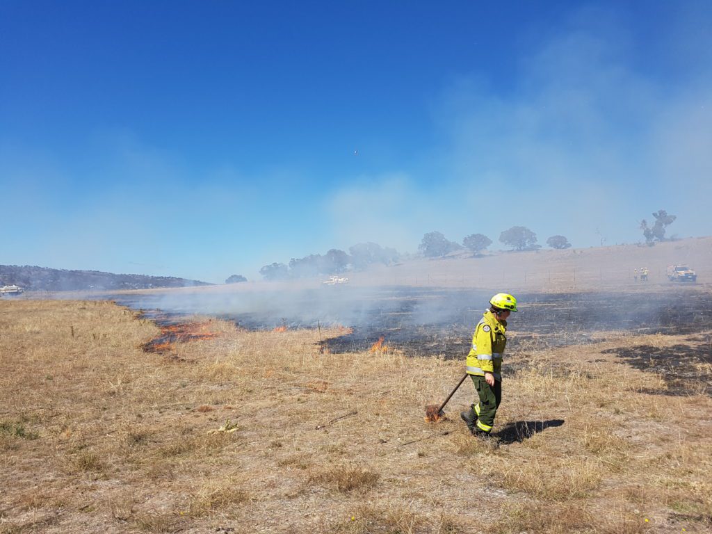
In their roles at the ACT PCS, Tony and the fire team generate models of data using previous fire histories and fire behaviour computer simulations and employ them to optimize future prescribed burn schedules. Prescribed, or planned burns are one method of hazard reduction where a carefully managed fire is carried out under mild conditions in order to reduce fuels such as dead wood, leaf litter, bark and shrubs. Other ways to physically remove fire fuels include mowing or grazing grasses, slashing shrubs, and trimming and cutting vegetation. The decreased amount of fuel lowers the potential intensity of a fire in an area, making it easier for fire crews to control.
Following the 2019-2020 fires, Tony says they will reassess the prescribed burn schedules for lands managed by the ACT PCS because the ‘residual risk’ has changed dramatically. Residual risk represents the percentage of the maximum bushfire risk (to life and property) that remains in the landscape after fuel reduction activities and bushfire have occurred. The concept of residual risk was established by land management agencies in Victoria after the 2009 Black Saturday Fires burnt over 400,000 hectares and has since been adopted elsewhere in Australia.
“By measuring the residual risk effect, we can now focus and balance bushfire fuel management activities, such as prescribed burning, on areas where it will have the greatest effectiveness in reducing risk to life, property and the environment,” says Tony.
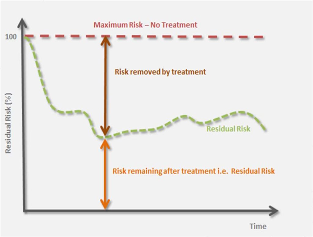
Residual risk represents the percentage of the maximum bushfire risk (to life and property) that remains in the landscape after fuel reduction activities and bushfire have occurred.
Modeling residual risk
Prior to the 2019-2020 fire season, Tony used the abundant data available after the fires that engulfed the ACT in January 2003 to verify the model against what happened as the fire spread in 2003 using the fuel loads available at the time. This helped to ascertain whether the model could be used as a realistic representation, and to look at scenarios where the residual risk was 100 percent.
Based on his extensive experience in Victoria, Tony utilised an interstate expert, Owen Salkin. Owen used Phoenix RapidFire, a bushfire simulator and risk assessment decision support tool developed by Kevin Tolhurst at the University of Melbourne, Victoria, to model proposed prescribed burns across the landscape based on pre-determined burn blocks. The models evaluate what effect they would have and how far potential bushfire impacts could spread.
“By modeling prescribed burning activities in various burn unit block configurations across the landscape, we can see the difference that they make to potential fire patterns,” says Tony.
Numerous variables and considerations determine the effectiveness of a burn in each block. For example, is it part of an important water catchment? Is it close to homes or vital infrastructure? What is the ecological value of each block and how is that taken into account? What is the tolerable fire interval and how soon can we repeat activities?
To optimize the burn schedule, Owen exported the simulations generated by Phoenix into Remsoft’s Woodstock Optimization Studio as a data table. Each burn unit in the landscape has certain characteristics, like a forestry compartment, including an associated risk score along with other key features such as aspect, vegetation type, burnability type and fuel load.
“We can run Woodstock and see what the overall effect is over a long time period to do the optimization there,” says Tony, “We can say that we want to minimize the risks score across the landscape, and that’s one of the optimization criteria that we use.”
By plugging the outputs from Owen’s Phoenix simulations into Woodstock, Tony is able to generate forest plans of when and where to undertake prescribed burning in the ACT for different timeframes between 10 and 40 years, and for each of the models he is able to focus on different criteria, such as minimizing property loss or ecological values to deliver a balanced outcome.
Talking to the neighbors
Of course, bushfires do not recognise state and territory borders and Tony and his team continue to work closely with colleagues in New South Wales (NSW), the state that encloses the ACT on all sides. Since the 2019-2020 fires passed through about 80 percent of ACT’s national parks, and considerable areas in surrounding NSW, the residual risk has been significantly reduced and planning will need to take this into account.
Tony says: “The bushfire risk now is reduced in those areas. You would expect minimal fire risk from there for at least the next five years or so.”
Fire management officers in the ACT and NSW are monitoring regrowth and fuel loads in the recently burnt areas and modeling years in advance to keep the overall risk scores for life and property under control whilst balancing ecological, environmental and water catchment values. The modelling needs to also deliver metrics which are transparent and repeatable and can be demonstrated to the public.
“The only way we can do that is using something like Woodstock,” says Tony.
Another critical component of this work is presenting the models generated in Woodstock to diverse stakeholders, such as fire and emergency response teams, government agencies, ecologists and affected communities.
Says Tony, “We’re trying to demonstrate, as effectively as we can, that we’re using the best tools that are available to us at the moment.”